
Lands of Geraz trails
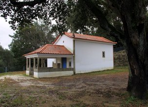
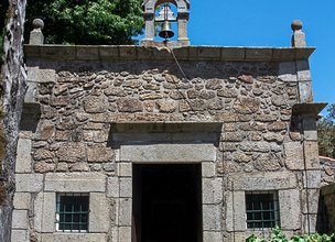
Located on the left bank of the Lima River, these lands were gifted by nature, with fertile soils, a mild climate and an abundant biodiversity that allowed human occupation over more than 2,000 years.
Under the current name of Parish union of Geraz do Lima (Stª Maria, Stª Leocádia and Moreira) and Deão, this region is an icon of the richness of rural life. Agriculture remains an activity of excellence and the quality of its products is the most evident proof of its value. The authentic flavor of the cereals and vineyards of the loureiro and vinhão grape varieties preserve ancient knowledge and flavors, perpetuated in the immense built heritage that stands out in the landscape.
Datasheet PR21 - Valley of Lima Trail
Duration: 4h00m
Distance: 15 km
Initial height: 25m
Minimum height: 394m
Maximum height: 25m
Difficulty level: Moderate
Category: Circular
Starting point: 41.707658, -8.675422
Informative leaflet: PR 21 - TRILHO VALE DO LIMA
Route in KMZ format for download: KMZ_PR21 TRILHO VALE DO LIMA

Location
União das Freguesias de Geraz do Lima (Santa Maria, Santa Leocádia e Moreira) e Deão
Coordinates
Lat: 41.707817
Long: -8.675533
 Theme
Theme
 Point of interest

Hello little one!
I'm Piquinhos and I can help you learn more about the Geopark!

Technical details
Child Mode
Discover the geopark in a simpler format, aimed at the little ones.
Clique ENTER para pesquisar ou ESC para sair