
Lands of Geraz trails
The trail, that starts in Geraz do Lima and continues towards Arga mountain, merges in part with the Royal way to Santiago de Compostela (Royal Way of St. James) - also known as the Northern Way or Srª do Norte.
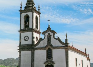
It is one of the most frequented trails in August, when one of the most popular festivals in Alto Minho is celebrated: S. João d’Arga. Departing from Lugar da Passagem or Embarcadouro de Lanheses next to the Lima River, it is possible to imagine the immense river traffic that anchored here until the middle of the 20th century. The boat “Água-arriba” and the 2 monoxyl pirogues of the 2nd or 3rd century BC, mentioned in the Ecomuseum, are indisputable landmarks of the strong connection to the river. Going up towards Arga mountain several Churches, Chapels and Alminhas (little shrines for the souls) are found at every step among the dense vegetation. The tour ends at the famous S. João d’Arga Monastery.
Datasheet PR22 -Pilgrims Trail
Duration: 7h00m
Distance: 24,5 km
Initial height: 10m
Minimum height: 585m
Maximum height: 10m
Difficulty level: Moderate
Category: Linear
Starting point: 41.723964, -8.675911
Informative leaflet: PR 22 - TRILHO DOS ROMEIROS
Route in KMZ format for download: KMZ_PR22 TRILHO DOS ROMEIROS
The trail, that starts in Geraz do Lima and continues towards Arga mountain, merges in part with the Royal way to Santiago de Compostela (Royal Way of St. James) - also known as the Northern Way or Srª do Norte.
It is one of the most frequented trails in August, when one of the most popular festivals in Alto Minho is celebrated: S. João d’Arga. Departing from Lugar da Passagem or Embarcadouro de Lanheses next to the Lima River, it is possible to imagine the immense river traffic that anchored here until the middle of the 20th century. The boat “Água-arriba” and the 2 monoxyl pirogues of the 2nd or 3rd century BC, mentioned in the Ecomuseum, are indisputable landmarks of the strong connection to the river. Going up towards Arga mountain several Churches, Chapels and Alminhas (little shrines for the souls) are found at every step among the dense vegetation. The tour ends at the famous S. João d’Arga Monastery.
Datasheet PR22 -Pilgrims Trail
Duration: 7h00m
Distance: 24,5 km
Initial height: 10m
Minimum height: 585m
Maximum height: 10m
Difficulty level: Moderate
Category: Linear
Starting point: 41.723964, -8.675911
Informative leaflet: PR 22 - TRILHO DOS ROMEIROS
Route in KMZ format for download: KMZ_PR22 TRILHO DOS ROMEIROS

Location
União das Freguesias de Geraz do Lima (Santa Maria, Santa Leocádia e Moreira) e Deão; União de freguesias de Nogueira, Meixedo e Vilar de Murteda, Lanheses e Montaria
Coordinates
Lat: 41.724494
Long: -8.6754
 Theme
Theme
 Point of interest

Hello little one!
I'm Piquinhos and I can help you learn more about the Geopark!

Technical details
Child Mode
Discover the geopark in a simpler format, aimed at the little ones.
Clique ENTER para pesquisar ou ESC para sair