
Castelo de Neiva trails
The “Castro de Moldes” (Castro – a fortified settlement) trail is a short-distance walking trail (PR13-portuguese acronym), part of a network of walking trails in Viana do Castelo. These are marked trails with international symbols and each has been numbered by the municipality.
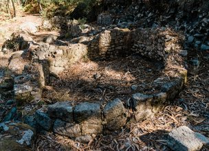
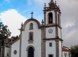
Located in the coastal village of Castelo do Neiva, in the municipality of Viana do Castelo, this trail takes visitors through some incredibly scenic areas where you may admire the beauty of nature, cultural heritage sites and archaeological remains. In addition to the unique landscapes over the river, the sea and the mountain that this trail offers, there are also signs of religiosity in the little shrines, cruises, chapels and the connection to the Portuguese Coastal route of El Camino de Santiago (Way of Saint James); the Palheiros de Sargaço (Seaweed Shacks); watermills, “Penedo das Chaves”; Castro de Moldes (fortified settlement); the Sebastião Bridge and the Parish Church.
Datasheet PR13 - Castro de Moldes Trail
Duration: 4h00m
Distance: 11,35 km
Difficulty level: Easy
Category: Circular
Starting point: 41.623869, -8.795128
Route in KMZ format for download: KMZ_PR13 TRILHO CASTRO DE MOLDES
The “Castro de Moldes” (Castro – a fortified settlement) trail is a short-distance walking trail (PR13-portuguese acronym), part of a network of walking trails in Viana do Castelo. These are marked trails with international symbols and each has been numbered by the municipality.
Located in the coastal village of Castelo do Neiva, in the municipality of Viana do Castelo, this trail takes visitors through some incredibly scenic areas where you may admire the beauty of nature, cultural heritage sites and archaeological remains. In addition to the unique landscapes over the river, the sea and the mountain that this trail offers, there are also signs of religiosity in the little shrines, cruises, chapels and the connection to the Portuguese Coastal route of El Camino de Santiago (Way of Saint James); the Palheiros de Sargaço (Seaweed Shacks); watermills, “Penedo das Chaves”; Castro de Moldes (fortified settlement); the Sebastião Bridge and the Parish Church.
Datasheet PR13 - Castro de Moldes Trail
Duration: 4h00m
Distance: 11,35 km
Difficulty level: Easy
Category: Circular
Starting point: 41.623869, -8.795128
Route in KMZ format for download: KMZ_PR13 TRILHO CASTRO DE MOLDES

Location
Castelo de Neiva
Coordinates
Lat: 41.623889
Long: -8.794908
 Theme
Theme
 Point of interest

Hello little one!
I'm Piquinhos and I can help you learn more about the Geopark!

Technical details
Child Mode
Discover the geopark in a simpler format, aimed at the little ones.
Clique ENTER para pesquisar ou ESC para sair