
Barroselas and Carvoeiro trails
The pedestrian trail "Trilho das Azenhas" is a short-distance trail (PR12 - portuguese acronym), integrated in the Municipal Network of Pedestrian trails of Viana do Castelo. These are marked and signaled trails according to international guidelines. The numbering is assigned by the Municipality of Viana do Castelo.
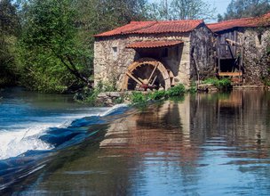
This trail is located in the parish of Barroselas, in Viana do Castelo Municipality and unveils the cultural and ecological richness of this village. Barroselas is located about 14 km from the city of Viana do Castelo, on the slope of "Serra da Padela" (Padela mountain), extending to the Neiva River. This route is complementary to the "Village Trail", implemented in this same parish. The watermills are large buildings with good masonry, which can be towed and whitewashed, with gabled roofs. They are located next to the rivers with the highest flow.
Datasheet PR12 - Watermills Trail
Duration: 3h00m
Distance: 6,47 km
Difficulty level: Easy
Category: Circular
Starting point: 41.647508, -8.700711
Route in KMZ format for download: KMZ_PR12 TRILHO DAS AZENHAS
The pedestrian trail "Trilho das Azenhas" is a short-distance trail (PR12 - portuguese acronym), integrated in the Municipal Network of Pedestrian trails of Viana do Castelo. These are marked and signaled trails according to international guidelines. The numbering is assigned by the Municipality of Viana do Castelo.
This trail is located in the parish of Barroselas, in Viana do Castelo Municipality and unveils the cultural and ecological richness of this village. Barroselas is located about 14 km from the city of Viana do Castelo, on the slope of "Serra da Padela" (Padela mountain), extending to the Neiva River. This route is complementary to the "Village Trail", implemented in this same parish. The watermills are large buildings with good masonry, which can be towed and whitewashed, with gabled roofs. They are located next to the rivers with the highest flow.
Datasheet PR12 - Watermills Trail
Duration: 3h00m
Distance: 6,47 km
Difficulty level: Easy
Category: Circular
Starting point: 41.647508, -8.700711
Route in KMZ format for download: KMZ_PR12 TRILHO DAS AZENHAS

Location
União de Freguesias de Barroselas e Carvoeiro
Coordinates
Lat: 41.647503
Long: -8.700372
 Theme
Theme
 Point of interest

Hello little one!
I'm Piquinhos and I can help you learn more about the Geopark!

Technical details
Child Mode
Discover the geopark in a simpler format, aimed at the little ones.
Clique ENTER para pesquisar ou ESC para sair