A STAIRCASE OF GIANTS
In the last 2.6 million years, more than 20 climatic cycles have been known, each corresponding to a hot period (interglacial) followed by a long cooling period that culminates in a glaciation.
The glacial periods correspond to low sea levels, the result of water retention in the terrestrial poles. On the contrary, interglacial periods correspond to higher sea levels, usually close to current values. Climatic evolution is strongly dependent on factors such as orbitals (with long periods of evolution) and solar irradiation or those related to ocean circulation (more frequently).
Coastal platforms are the result of successive episodes of marine modeling and tectonic uplift.
When the sea level remains in the same relative position in relation to a rocky mass, the intense activity of the waves creates a planar surface as a result of this wear and chemical change. Its preservation is possible due to the drop of sea levels, which frees it from the mechanical force of the waves and the seismic activity that normally causes its lifting.
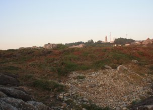
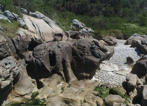
The granitic substrate that makes up this Natural Monument, corresponds to a rock more resistant to the processes of weathering and erosion, preserving the scaling traces of its coastal landscape.
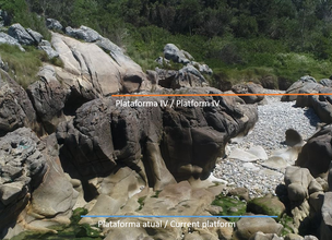
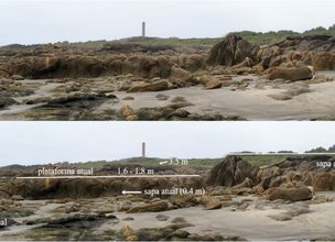
Currently, four levels of coastal platforms are identified above the current one, the 18 m (I), 13 m (II), 8 m (III) and 5 m (IV) platform. Based on studies carried out in the region, they are considered to correspond to the successive interglacials that are known today and 410 thousand years ago (Carvalhido, 2012, 2014a,b,c,d).
References:
Carvalhido (2012). O Litoral Norte de Portugal (Minho-Neiva): evolução paleoambiental quaternária e proposta de conservação do património geomorfológico. Tese de Doutoramento, Universidade do Minho, 564 p.
Carvalhido, R.; Pereira, D. & Cunha, P. (2014a) – Depósitos costeiros quaternários do noroeste de Portugal (Minho - Neiva): caracterização datação e interpretação paleoambiental. Comunicações Geológicas (2014) 101, Especial II, 605–609.
Carvalhido, R.; Brilha, J. & Pereira, D. (2014b) – Monumentos Naturais Locais de Viana do Castelo: processo de classificação e estratégias de valorização. Comunicações Geológicas (2014) 101, Especial III, 1219–1223.
Carvalhido, R.; Pereira, D; Cunha, P.; Buylaert, J. & Murray, A. (2014c) Characterization and dating of coastal deposits of NW Portugal (Minho-Neiva area): a record of climate, eustasy and crustal uplift during the Quaternary. Quat Int, 328-329: 94–106
Carvalhido, Ricardo (2014d). Processo de classificação dos 5 Monumentos Naturais Locais de Viana do Castelo. Memória Descritiva. Câmara Municipal de Viana do Castelo.
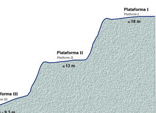
Altimetric profile of the levels of preserved coastal platforms in Montedor
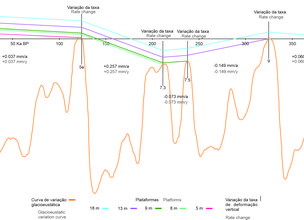
The graphical interpretation makes it possible to determine the rate of vertical deformation of the coastal platforms identified in this monument. Between 410 000 years and today, the survey will have occurred at an average rate of 0.0487 mm / year. The graph depicted suggests that the vertical deformation will have occurred with several rate and regime changes.
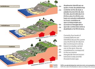
Coastal platform formation scheme
Location
Carreço
Coordinates
Lat: 41.7485064
Long: -8.8784156
Hello little one!
I'm Piquinhos and I can help you learn more about the Geopark!
Technical details
A STAIRCASE OF GIANTS
Climatic variability has been a fact over geological time, recognizing the alternation between glacial and interglacial periods since the Precambrian. The upper Paleozoic glaciation, between the Carbónico and the Pérmico, was probably the most extensive of the last 540 Ma, assuming that the ice mass may have covered, according to data from Horton & Poulsen (2009), the corresponding area between the South Pole and the current latitude of Buenos Aires (≈35ºS), causing an eustatic adjustment of approximately -100 m, with reference to the current level. During the Mesozoic-Cenozoic, more than 28 disturbances of the geological record are recognized, induced by global variations in sea level (Vail et al., 1980).
The understanding and predictability of the glacial cycles phenomenon was enlarged from the beginning of the last century with the contribution of Milankovitch, whose studies demonstrated the influence of astronomical factors, namely the planet's orbital geometry, of cyclic behavior, in the global climate of the planet. Hays et al. (1976) state that the planet's orbital geometry is the fundamental cause for the succession of glaciations during the Quaternary, since it affects the amount of radiation received by the Earth's surface, inducing glacioeustatic oscillations.
References and scientific articles
Carvalhido, R. (2012). O Litoral Norte de Portugal (Minho-Neiva): evolução paleoambiental quaternária e proposta de conservação do património geomorfológico. Universidade do Minho.
Hays, J.; Imbrie, J. & Shackleton, N. (1976). Variations in the Earth’s orbit: Pacemaker of the ice ages. Science, 194(4270), 1121–1132.
Horton, D. & Poulsen, C. (2009). Paradox of late Paleozoic glacioeustasy. Geology, 37, 715-718, doi: 10.1130/G30016A.1.
Vail, P.; Mitchum, R.; Shipley, T. & Buffler, R. (1980). Unconformities of the North Atlantic. Philosophical Transactions of the Royal Society in London, A294 (1980), pp. 137–155.
Altimetric profile of the levels of preserved coastal platforms in Montedor
The graphical interpretation makes it possible to determine the rate of vertical deformation of the coastal platforms identified in this monument. Between 410 000 years and today, the survey will have occurred at an average rate of 0.0487 mm / year. The graph depicted suggests that the vertical deformation will have occurred with several rate and regime changes.
Coastal platform formation scheme
Child Mode
Discover the geopark in a simpler format, aimed at the little ones.
Clique ENTER para pesquisar ou ESC para sair
