
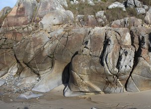
A HANGING BEACH
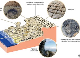
In the Natural Monument of Montedor we can see the evidence of the erosive action of the Atlantic on the rocks, during the last interglacial period 130 to 115 thousand years ago (Eemian period).
These records occur in the form of polished surfaces, slightly sloped towards the ocean and invariably between altitudes of 2 to 3.5 m and 4.5 to 5.5 m above the current sea level.
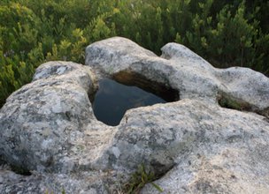
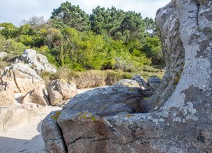
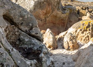
At the same altitude of these platforms, depressions dug in the granites are conserved, the potholes, that result from the combination of the kinetic force of the waves with the pebbles and boulders that are found there. The movement of circulation of these sediments leads to the deepening and widening of these structures over time. In the corridors that isolated the eemian surface on several platforms, the bursting jet prints an excavation in these walls, making them concave, so these geoforms – notches – are excellent markers of the existence and position of sea levels.
The marine origin of these platforms is also confirmed by the existence of ichnofossils like housing cavities of sea urchins such as the Paracentrotus lividus (Carvalhido, 2012, 2014a,b).
References:
Carvalhido (2012). O Litoral Norte de Portugal (Minho-Neiva): evolução paleoambiental quaternária e proposta de conservação do património geomorfológico. Tese de Doutoramento, Universidade do Minho, 564 p.
Carvalhido, R.; Brilha, J. & Pereira, D. (2014a) – Monumentos Naturais Locais de Viana do Castelo: processo de classificação e estratégias de valorização. Comunicações Geológicas (2014) 101, Especial III, 1219–1223.
Carvalhido, Ricardo (2014b). Processo de classificação dos 5 Monumentos Naturais Locais de Viana do Castelo. Memória Descritiva. Câmara Municipal de Viana do Castelo.
In the Natural Monument of Montedor we can see the evidence of the erosive action of the Atlantic on the rocks, during the last interglacial period 130 to 115 thousand years ago (Eemian period).
These records occur in the form of polished surfaces, slightly sloped towards the ocean and invariably between altitudes of 2 to 3.5 m and 4.5 to 5.5 m above the current sea level.
At the same altitude of these platforms, depressions dug in the granites are conserved, the potholes, that result from the combination of the kinetic force of the waves with the pebbles and boulders that are found there. The movement of circulation of these sediments leads to the deepening and widening of these structures over time. In the corridors that isolated the eemian surface on several platforms, the bursting jet prints an excavation in these walls, making them concave, so these geoforms – notches – are excellent markers of the existence and position of sea levels.
The marine origin of these platforms is also confirmed by the existence of ichnofossils like housing cavities of sea urchins such as the Paracentrotus lividus (Carvalhido, 2012, 2014a,b).
References:
Carvalhido (2012). O Litoral Norte de Portugal (Minho-Neiva): evolução paleoambiental quaternária e proposta de conservação do património geomorfológico. Tese de Doutoramento, Universidade do Minho, 564 p.
Carvalhido, R.; Brilha, J. & Pereira, D. (2014a) – Monumentos Naturais Locais de Viana do Castelo: processo de classificação e estratégias de valorização. Comunicações Geológicas (2014) 101, Especial III, 1219–1223.
Carvalhido, Ricardo (2014b). Processo de classificação dos 5 Monumentos Naturais Locais de Viana do Castelo. Memória Descritiva. Câmara Municipal de Viana do Castelo.

Geoform scheme of beach dynamics.
Location
Praia de Fornelos, Carreço
Coordinates
Lat: 41.7470185
Long: -8.8768017
 Theme
Theme
 Point of interest

Hello little one!
I'm Piquinhos and I can help you learn more about the Geopark!

Technical details
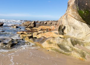
A HANGING BEACH
The knowledge of the tidal pattern is essential for the understanding, analysis and interpretation of coastal platforms, since and according to Trenhaile (1997), the peak of erosive action corresponds to the level most frequently occupied by the water plane. The amplitude of the tide is essentially associated with: 1) astronomical factors, related to the relative position between the Moon, the Earth and the Sun; 2) meteorological factors, essentially the winds intensity and direction; 3) fluctuations in atmospheric pressure and 4) geomorphological factors, associated with the shape of the basins (Pugh, 1996). The higher amplitudes of the tides are essentially associated with the conjugation phenomena between the three stars (sizígia tide - living waters) and opposition (dead waters), arising from the quadrature (First Quarter Moon and Third Quarter Moon) and increased in the periods close to the equinoxes.
According to Araújo & Gomes (2009), the coastal platforms development shows a good correlation with the average quotas measured at low tide and slightly above those measured at high tide. The identification of the staggering of Viana do Castelo's coastal platforms was made possible through detailed mapping of structural alignments and hydrodynamic geoforms, namely pothole and basal notches.
References and scientific articles
Araújo, M. A. & Gomes, A. (2009). The use of the GPS in the identification of fossil shore platforms and its tectonic deformation: an example from the Northern Portuguese coast. Journal of Coastal Research, SI 56 (Proceedings of the 10th International Coastal Symposium). Lisbon, Portugal.
Carvalhido, R. (2012). O Litoral Norte de Portugal (Minho-Neiva): evolução paleoambiental quaternária e proposta de conservação do património geomorfológico. Universidade do Minho.
Pugh, D. (1996). Tides, Surges and Mean Sea-Level. John Wiley and Sons Ltd, Chichester, UK.
Trenhaile, A. (1997). Coastal Dynamics and Landforms. Oxford University Press, Oxford UK, 366 pp.
Geoform scheme of beach dynamics.
Child Mode
Discover the geopark in a simpler format, aimed at the little ones.
Clique ENTER para pesquisar ou ESC para sair