
(on) Porphyritic granite (500 years b.C.)
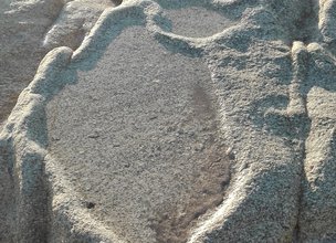
The Local Natural Monument of Ribeira de Anha preserves the occurrence of several clusters of salt pans dating from the Iron Age. The pans or bowls provide important paleoenvironmental information, namely on the relative position of the sea level during the Iron Age, which would be lower than the current one.
The pans or bowls were sculpted in the rock through a chipping process with variable dimensions and shapes, taking advantage of the surfaces available in the rocks, being able to assume a sub-rectangular, trapezoidal or even semicircular shape. Regarding depth, it is estimated that they would be between 5 to 10 cm, with the purpose of containing a minimum amount of water that would allow easy and rapid evaporation (Almeida, 2009). As for the location, the salt pans would be above the high tide line, preventing it from flooding when it reached the maximum level. This fact leads us to see that the way they work, consisted of an indirect flooding system, according to which salt explorers would flood the pans with water they transported from the sea.
Several of these findings are today submerged during the high tide, indicating that about four to five thousand years ago, during the Iron Age, the sea level would probably be about 1 to 2 meters below the position current. In this way, these relics are indicators of the position and evolution of the coastline along recent geological time.

Location
Coordinates
Lat: 41.673476
Long: -8.825872
 Theme
Theme
 Point of interest

Hello little one!
I'm Piquinhos and I can help you learn more about the Geopark!

Technical details
Child Mode
Discover the geopark in a simpler format, aimed at the little ones.
Clique ENTER para pesquisar ou ESC para sair