
Outeiro trails
The Saint Martinho of Outeiro trail is a pedestrian short-distance trail (PR18 - Portuguese acronym), so the respective marking and signage obeys international standards. The numbering is assigned by the Municipality of Viana do Castelo.
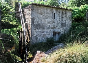
This route is located in the parish of Outeiro, in the municipality of Viana do Castelo. Small route that reveals the patrimonial and environmental richness of the parish of Outeiro, with passage through chapels, watermills and museological nucleus.
Datasheet PR18 - Saint Martinho of Outeiro Trail
Duration: 5h00m
Distance: 14,32 km
Difficulty level: Hard
Category: Circular
Starting point: 41.749869, -8.781486
Route in KMZ format for download: KMZ_PR18 TRILHO S. MARTINHO DE OUTEIRO
The Saint Martinho of Outeiro trail is a pedestrian short-distance trail (PR18 - Portuguese acronym), so the respective marking and signage obeys international standards. The numbering is assigned by the Municipality of Viana do Castelo.
This route is located in the parish of Outeiro, in the municipality of Viana do Castelo. Small route that reveals the patrimonial and environmental richness of the parish of Outeiro, with passage through chapels, watermills and museological nucleus.
Datasheet PR18 - Saint Martinho of Outeiro Trail
Duration: 5h00m
Distance: 14,32 km
Difficulty level: Hard
Category: Circular
Starting point: 41.749869, -8.781486
Route in KMZ format for download: KMZ_PR18 TRILHO S. MARTINHO DE OUTEIRO

Location
Outeiro
Coordinates
Lat: 41.749911
Long: -8.781506
 Theme
Theme
 Point of interest

Hello little one!
I'm Piquinhos and I can help you learn more about the Geopark!

Technical details
Child Mode
Discover the geopark in a simpler format, aimed at the little ones.
Clique ENTER para pesquisar ou ESC para sair