
Darque trails
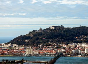
The Monte Galeão trail is a pedestrian short-distance trail (PR17 - Portuguese acronym), so the respective marking and signage obeys international standards. The numbering is assigned by the Municipality of Viana do Castelo. This route is located in the parish of Darque, in the municipality of Viana do Castelo. Very interesting little mountain trail, due to the fact that it crosses a patch of very varied vegetation and with stunning views over the Lima River and the city of Viana do Castelo.
Datasheet PR17 - Monte Galeão Trail
Duration: 2h00m
Distance: 2,43 km
Difficulty level: Moderate
Category: Circular
Starting point: 41.677647, -8.793583
Route in KMZ format for download: KMZ_PR17 TRILHO DO MONTE GALEAO

Location
Darque
Coordinates
Lat: 41.680175
Long: -8.797139
 Theme
Theme
 Point of interest

Hello little one!
I'm Piquinhos and I can help you learn more about the Geopark!

Technical details
Child Mode
Discover the geopark in a simpler format, aimed at the little ones.
Clique ENTER para pesquisar ou ESC para sair