
The formation and evolution of Poço Negro waterfalls in relation to the variation of sea level and the evolution of ancient coastal cliff
How Poço Negro cascades have formed?
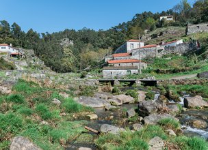
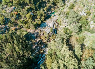
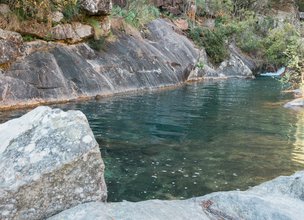
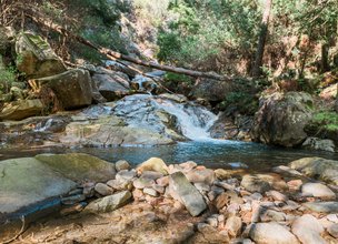
Poço Negro cascades (Poço negro means black well) are located in Pêgo stream and are related to na old coastal cliff. The waterfalls are located in the most entrenched section of Pêgo stream (Figs. 1 and 2).
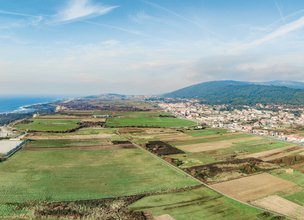
This section connects ancient higher erosion platforms (above 100 meters) with the actual coastal platform that is being formed (below 60 meters) (Fig. 3 and Esq. 1 and 2).
Cascades are a particular type of waterfall where the water comes down along a series of steps naturally excavated in the rock. Such is the case of Poço Negro Cascades. Their origin is related to the marked decrease in the average temperature of the Earth that took place about 2.5 million years ago. It was the beginning of a glacial period, the Quaternary, which is still ongoing. The decrease in temperature led to water retention in the form of ice next to the poles and in the mountains. As a consequence, there was a fall in sea level. Sea level fall in the western coast of the Iberian Peninsula was a determining factor in the origin of Poço Negro Cascades according to a process similar to the one depicted in scheme 3, where:
A) About 20 million years ago, when climate was warmer than today, sea level was higher.
B) In the course of time, tectonics lifted the continent in relation to sea level.
C) As a consequence, several flattened surfaces were formed due to sea erosion.
D) About 2.5 million years ago, a period of global cooling occurred; as a consequence, sea level
dropped.
E) At the same time, tectonics continued to lift the continent.
F) The fast sea level fall originated the costal cliff where Poço do Negro cascades are located.
G) Eighteen thousand years ago, sea level was about 130 meters below today’s level, and the coast line was 40 km from the current position. Since then, sea level has risen.
H) These cascades were formed due to a fast sea level fall and the consequent formation of a costal cliff.
How Poço Negro cascades have formed?
Poço Negro cascades (Poço negro means black well) are located in Pêgo stream and are related to na old coastal cliff. The waterfalls are located in the most entrenched section of Pêgo stream (Figs. 1 and 2).
This section connects ancient higher erosion platforms (above 100 meters) with the actual coastal platform that is being formed (below 60 meters) (Fig. 3 and Esq. 1 and 2).
Cascades are a particular type of waterfall where the water comes down along a series of steps naturally excavated in the rock. Such is the case of Poço Negro Cascades. Their origin is related to the marked decrease in the average temperature of the Earth that took place about 2.5 million years ago. It was the beginning of a glacial period, the Quaternary, which is still ongoing. The decrease in temperature led to water retention in the form of ice next to the poles and in the mountains. As a consequence, there was a fall in sea level. Sea level fall in the western coast of the Iberian Peninsula was a determining factor in the origin of Poço Negro Cascades according to a process similar to the one depicted in scheme 3, where:
A) About 20 million years ago, when climate was warmer than today, sea level was higher.
B) In the course of time, tectonics lifted the continent in relation to sea level.
C) As a consequence, several flattened surfaces were formed due to sea erosion.
D) About 2.5 million years ago, a period of global cooling occurred; as a consequence, sea level
dropped.
E) At the same time, tectonics continued to lift the continent.
F) The fast sea level fall originated the costal cliff where Poço do Negro cascades are located.
G) Eighteen thousand years ago, sea level was about 130 meters below today’s level, and the coast line was 40 km from the current position. Since then, sea level has risen.
H) These cascades were formed due to a fast sea level fall and the consequent formation of a costal cliff.

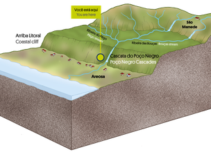
Esq. 1 - Location of Poço Negro waterfalls.
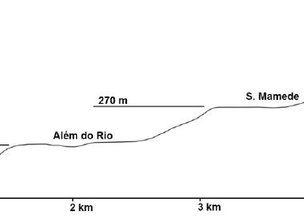
Esq. 2 - Longitudinal profile (Vertical scale is exaggerated) highlighting the sharp slope in Pêgo stream section and several erosion platforms located between Saint Luzia plateau and the beach (Carvalhido, 2012).
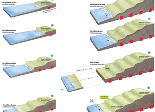
Esq. 3 - Evolution of Viana do Castelo north coast and origin of Poço Negro waterfalls (see explanations in the text).
Location
Areosa
Coordinates
Lat: 41.72317371314491
Long: -8.848440539659673
 Theme
Theme
 Point of interest

Hello little one!
I'm Piquinhos and I can help you learn more about the Geopark!

Technical details
Esq. 1 - Location of Poço Negro waterfalls.
Esq. 2 - Longitudinal profile (Vertical scale is exaggerated) highlighting the sharp slope in Pêgo stream section and several erosion platforms located between Saint Luzia plateau and the beach (Carvalhido, 2012).
Esq. 3 - Evolution of Viana do Castelo north coast and origin of Poço Negro waterfalls (see explanations in the text).
Child Mode
Discover the geopark in a simpler format, aimed at the little ones.
Clique ENTER para pesquisar ou ESC para sair