
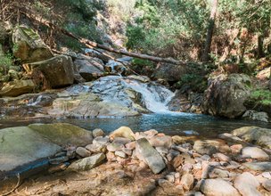
The origin of the Poço Negro Cascades
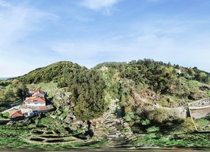
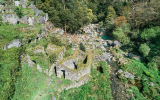
The Local Natural Monument (52 ha) is located in the parish of Areosa, upstream of Quinta da Boa Viagem (surface of Vila Fria, 50 m) and extends to the area of Além do Rio, a structural surface developed at an altitude of 160 m and at this location it has its greatest development (Surface of the Além do Rio, 160 m) (Carvalhido & Pereira, 2015).
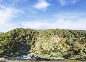
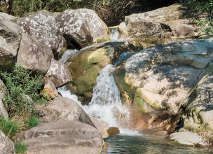
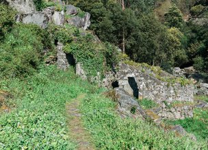
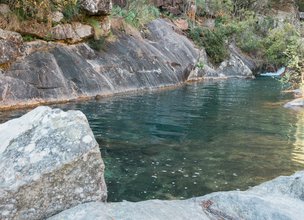
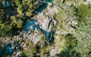
The Pêgo stream that crosses the highest cliff of the Santa Luzia mountain range according to NE-SW, presents itself in a very embedded section, typical of headland areas, assuming the peculiarity of occurring just over 1500 m from the current beach. The Pêgo course has an average slope of 12.5% (~ 51°). The geomorphic analysis indicates several important knickpoints in the main course, which correspond to successions of natural cascades (several with wells).
The upstream area of the geosite preserves the capture of the Bouças - Pêgo fluvial, due to the tilting of the Surface of the Além do Rio to the south (Carvalhido, 2012, 2015). The effect of headward erosion from the Lima basin and the probable structural control of the Pêgo fault (inverse; to the north) are involved in the tipping effect of this surface and in the observed capture.
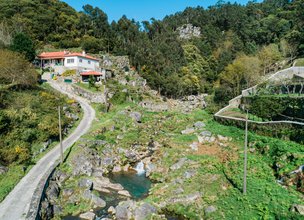
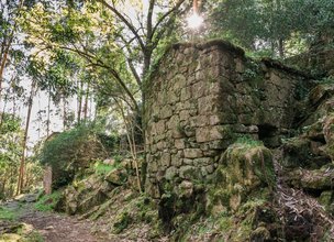
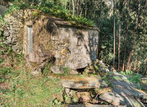
From a geocultural interest point of view, it is to be noted the grooves in the granitic pavement of the waterfalls that were produced by the continuous abrasion of the wheels of animal-drawn transport carriages to the various water mills in the area.
References:
Carvalhido, R. & Pereira, D. (2015). Contributo dos índices geomórficos para o conhecimento da geomorfologia do Litoral do Noroeste de Portugal. VII Congresso Nacional de Geomorfologia, Livro de Atlas IX, Associação Portuguesa de Geomorfólogos, Lisboa. ISSN: 978-989-96462-6-1.
Carvalhido (2012). O Litoral Norte de Portugal (Minho-Neiva): evolução paleoambiental quaternária e proposta de conservação do património geomorfológico. Tese de Doutoramento, Universidade do Minho, 564 p.
The Local Natural Monument (52 ha) is located in the parish of Areosa, upstream of Quinta da Boa Viagem (surface of Vila Fria, 50 m) and extends to the area of Além do Rio, a structural surface developed at an altitude of 160 m and at this location it has its greatest development (Surface of the Além do Rio, 160 m) (Carvalhido & Pereira, 2015).
The Pêgo stream that crosses the highest cliff of the Santa Luzia mountain range according to NE-SW, presents itself in a very embedded section, typical of headland areas, assuming the peculiarity of occurring just over 1500 m from the current beach. The Pêgo course has an average slope of 12.5% (~ 51°). The geomorphic analysis indicates several important knickpoints in the main course, which correspond to successions of natural cascades (several with wells).
The upstream area of the geosite preserves the capture of the Bouças - Pêgo fluvial, due to the tilting of the Surface of the Além do Rio to the south (Carvalhido, 2012, 2015). The effect of headward erosion from the Lima basin and the probable structural control of the Pêgo fault (inverse; to the north) are involved in the tipping effect of this surface and in the observed capture.
From a geocultural interest point of view, it is to be noted the grooves in the granitic pavement of the waterfalls that were produced by the continuous abrasion of the wheels of animal-drawn transport carriages to the various water mills in the area.
References:
Carvalhido, R. & Pereira, D. (2015). Contributo dos índices geomórficos para o conhecimento da geomorfologia do Litoral do Noroeste de Portugal. VII Congresso Nacional de Geomorfologia, Livro de Atlas IX, Associação Portuguesa de Geomorfólogos, Lisboa. ISSN: 978-989-96462-6-1.
Carvalhido (2012). O Litoral Norte de Portugal (Minho-Neiva): evolução paleoambiental quaternária e proposta de conservação do património geomorfológico. Tese de Doutoramento, Universidade do Minho, 564 p.

Location
Ribeira do Pêgo River Basin, parish of Areosa
Coordinates
Lat: 41.7326475
Long: -8.8471995
 Theme
Theme
 Point of interest
Themes
Discover all the themes of Poço Negro Cascades

Ecological Recovery
The following proposal was presented by the Mayor of the Chamber:- "PROPOSAL - Cooperation Protocol within the scope of the Progama de Reabilitação de Áreas Classificadas do concelho de Viana do Castelo - Responsabilidade ambiental no âmbito das áreas classificadas do concelho de Viana do Castelo".
In the scope of the Municipal Strategy for Nature Conservation, a plan inscribed in the ongoing Environment and Biodiversity Agenda for the four-year period 2017-2021, the Municipality prepared the Programa de Reabilitação Ecológica das Áreas Classificadas do concelho, in this first phase, focusing on 5 of the 13 Natural Monuments, unique areas for the knowledge of the geological history of the Iberian Peninsula since more than 500 million years ago and which are part of the application that the Municipality is preparing for recognition as a UNESCO World Geopark territory. Viana do Castelo is a rich territory from the point of view of Natural and Cultural Heritage, with about 4,800 hectares specifically designated for the protection of fauna and flora habitats (3 sites of Community importance of Natura 2000 Network), being the only municipality in the country with the geological heritage inventory concluded and duly classified with 13 natural monuments, making up a total area of about 2,832 hectares. The recovery programme that was drawn up supported an application to PO SEUR, with approval of the overall investment amount of 500,000 euros, financed at 85%, with implementation in 2020 and 2021. The ecological recovery interventions that are intended to be carried out include actions to eradicate and control exotic species, mainly Acacia dealbata (Mimosa), Acacia longifolia (Acacia longifolia) and Acacia Melanoxylon (Australia), Carpobrotus edulis (beach weevil), Arundo donax (giant reed), Trandescantia fluminencis (Fortune grass or tradescância) and Cortaderia selloana (pampas grass or plumas). In addition to these actions, supported by an exhaustive inventory carried out by the Municipality for those species, the programme includes actions to promote scientific literacy to the population and the densification of the Municipality's Citizen Science strategy, extending the Bioregisto platform to the cartography of invasive vegetation, in collaboration with the Functional Ecology Centre of the University of Coimbra (invasoras.pt). In addition, planting actions are planned in the areas to be ecologically intervened, namely native species such as oak, pine, hawthorn, holm oak, birch or heather, among others, within the scope of the Municipal Year for the Recovery of Portuguese Native Forests, currently underway. In order to guarantee the perennial success of the intervention and the investment made, the rehabilitation programme foresees the involvement of the social and business fabric, and within the scope of the environmental responsibility of the institutions, so that they may take responsibility for the maintenance of the ecological quality of all or parts of the classified areas of the municipality of Viana do Castelo. The programme for the ecological rehabilitation of the classified areas of Viana do Castelo - 1st phase - was carried out with the collaboration of the Parish Councils of Afife, Carreço, Darque, Vila Nova de Anha and Santa Marta de Portuzelo, and also with the Parish Councils of Mazaferes and Vila Fria and the Parish Councils of Viana do Castelo (Santa Maria Maior and Monserrate) and Meadela. The Associação de Caçadores de Vila Nova de Anha and the Comissão Diretiva dos Baldios da Montaria were also partners.

Hello little one!
I'm Piquinhos and I can help you learn more about the Geopark!

Technical details
Child Mode
Discover the geopark in a simpler format, aimed at the little ones.
Clique ENTER para pesquisar ou ESC para sair