
Formation and evolution of Galeão Dunes.
The area south of Lima River, between the sea and Galeão Hill, is covered by a sandy deposit. The upper part of this deposit seems to have been deposited during a colder climate, known as the Little Ice Age that took place approximately between 1300 and 1850.
Although the causes for the Little Ice Age are still a matter of debate, it seems to have started due to volcanic activity and has been maintained due to low solar activity.
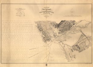
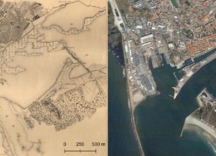
During the Little Ice Age, it is estimated that the sea was between 20 to 80 cm below the current level. During this period, it is very likely that, due to storms with heavy rain / snow, sedimentation increased along the river valleys, thus contributing to the supply of sediments in beaches. The abundance of sediments on the Lima River estuary was still visible in the year 1856, as it was represented in the map of figure 1. This map clearly represents a large amount of sediment in the riverbed beyond the Saint Lourenço Chapel, being the channel width considerably narrower than today (Fig. 2).
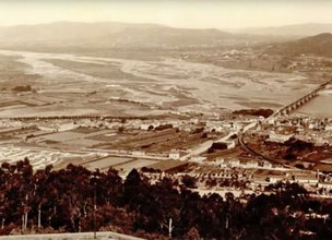
The existence of narrow channels and the large amount of sediment in the riverbed are still visible in figure 3, which reproduces a photograph of the first decade of the 20th century, contemporary of the first phase of construction of Santa Luzia Sanctuary.
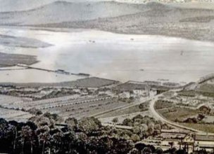
Figure 4 is a 19th century representation of the Lima riverbed, probably during high tide, and in which the sparse vegetation of the hills on the south bank of the river and extensive unforested white patches is visible.
The sediments carried by the Lima River are deposited in coastal areas creating wide beaches. The abundance of sediment on the beaches and on the riverbed, coupled with strong winds that would have been felt during the Little Ice Age, will have allowed the mobilization of sediment that gave rise to extensive coastal dunes. Since sea level was then lower than at present, there has also been an increase in the area of the beaches, a circumstance that would have provided even more sand for the dune development. This context was fundamental for the formation of most recent dunes in the Portuguese northwest coast. The dating of samples taken from these formations fits this time frame, and the sediment was most likely deposited between the 16th and 19th centuries.
The Faro de Anha dunes resulted of the abundance of sediment combined with the morphology of the terrain, gently sloping to the top of Galeão hill, and the absence of obstacles to wind transport (namely vegetation) to form coastal dunes and climbing dunes.
The area south of Lima River, between the sea and Galeão Hill, is covered by a sandy deposit. The upper part of this deposit seems to have been deposited during a colder climate, known as the Little Ice Age that took place approximately between 1300 and 1850.
Although the causes for the Little Ice Age are still a matter of debate, it seems to have started due to volcanic activity and has been maintained due to low solar activity.
During the Little Ice Age, it is estimated that the sea was between 20 to 80 cm below the current level. During this period, it is very likely that, due to storms with heavy rain / snow, sedimentation increased along the river valleys, thus contributing to the supply of sediments in beaches. The abundance of sediments on the Lima River estuary was still visible in the year 1856, as it was represented in the map of figure 1. This map clearly represents a large amount of sediment in the riverbed beyond the Saint Lourenço Chapel, being the channel width considerably narrower than today (Fig. 2).
The existence of narrow channels and the large amount of sediment in the riverbed are still visible in figure 3, which reproduces a photograph of the first decade of the 20th century, contemporary of the first phase of construction of Santa Luzia Sanctuary.
Figure 4 is a 19th century representation of the Lima riverbed, probably during high tide, and in which the sparse vegetation of the hills on the south bank of the river and extensive unforested white patches is visible.
The sediments carried by the Lima River are deposited in coastal areas creating wide beaches. The abundance of sediment on the beaches and on the riverbed, coupled with strong winds that would have been felt during the Little Ice Age, will have allowed the mobilization of sediment that gave rise to extensive coastal dunes. Since sea level was then lower than at present, there has also been an increase in the area of the beaches, a circumstance that would have provided even more sand for the dune development. This context was fundamental for the formation of most recent dunes in the Portuguese northwest coast. The dating of samples taken from these formations fits this time frame, and the sediment was most likely deposited between the 16th and 19th centuries.
The Faro de Anha dunes resulted of the abundance of sediment combined with the morphology of the terrain, gently sloping to the top of Galeão hill, and the absence of obstacles to wind transport (namely vegetation) to form coastal dunes and climbing dunes.

Location
Anha
Coordinates
Lat: 41.67775
Long: -8.8032329
 Theme
Theme
 Point of interest

Hello little one!
I'm Piquinhos and I can help you learn more about the Geopark!

Technical details
Child Mode
Discover the geopark in a simpler format, aimed at the little ones.
Clique ENTER para pesquisar ou ESC para sair