
Salt on Iron
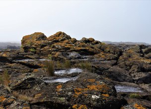
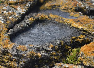
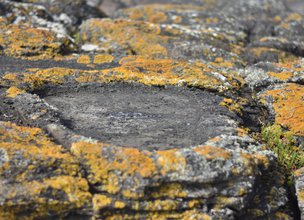
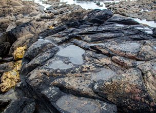
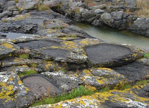
In this Local Natural Monument more than 700 salt pans of several dimensions and shapes (sub-rectangular, trapezoidal and semicircular) are preserved, built above the high water line, so as not to be flooded directly by the sea.
In this geosite, the pans occur carved in schist, a rock less permeable and with a greater thermal capacity than granite where these records are also known (Local Natural Monument Cemetery of Ancient Beaches of Alcantilado de Montedor).
Salt pans were used, transporting water to them. Over time, the heat of the sun and the wind allowed the water to evaporate, increasing the concentration of salt that was grouped in crystals and obtaining an unrefined coarse salt.
With occupation known at least since the Iron Age (the period that preceded the Romanization), the population of Cidade Velha and other local villages already subsisted on agriculture and livestock, so the production of salt was essential for the conservation of meat, which is assumed by the pans of the same age.
Today many of these findings are submerged during high tide, indicating that about four to five thousand years ago, during the Iron Age, the sea level would probably be about 1 to 2 meters below the current position. Thus, these relics are indicators of the position and evolution of the coastline over recent geological time.
References:
Almeida, Carlos Alberto Brochado (2009). Sítios que Fazem História - Arqueologia do Concelho de Viana do Castelo. Viana do Castelo: Câmara Municipal de Viana do Castelo.
Carvalhido (2018). Livro de Pedra, Monumentos Naturais Locais de Viana do Castelo – Catálogo. Câmara Municipal de Viana do Castelo, 2ª edição.
Costa, M.; Machado, J.; Lopes, H. & Almeida, T. (2012). Pias Salineiras da Praia do Canto Marinho: Inventário Arqueológico. Cadernos Vianenses, 46, 95–111.

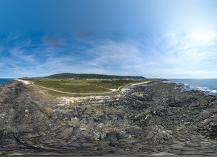
Location
Canto Marinho
Coordinates
Lat: 41.7281405
Long: -8.8709958
 Theme
Theme
 Point of interest

Hello little one!
I'm Piquinhos and I can help you learn more about the Geopark!

Technical details
In the area of the Natural Monument of the Magmatic Drops of Canto Marinho there are more than 700 salt sinks of pre-Roman age (Costa et al., 2012) which, in addition to the archaeological importance, are an important paleoenvironmental indicator of the pre-Roman period, and allow indicate that about 4 to 5,000 years ago the sea level would have been 1 to 2 meters below the current position (Carvalhido, 2018).
The pans or bowls were carved into the rocks through a chipping process, having several irregular shapes from the sub-rectangular, trapezoidal or even semicircular with little depth, between 5 to 10 cm (Almeida, 2009).
The pans or bowls were always located above the high tide line, so as not to flood directly. These were filled by transporting sea water to them, which over time, the heat from the sun and the wind allowed the water to evaporate, increasing the concentration of salt that was grouped into crystals, obtaining unrefined coarse salt (Costa et al ., 2012).
These archaeological finds can be found along the coastal coast of Viana do Castelo, however in this place the pans or bowls were carved in schist, a more impermeable rock and with greater thermal capacity than granite where these records are also known (LNM Alcantilado de Montedor, LNM Ribeira da Anha).
References and scientific articles
Almeida, Carlos Alberto Brochado (2009). Sítios que Fazem História - Arqueologia do Concelho de Viana do Castelo. Viana do Castelo: Câmara Municipal de Viana do Castelo.
Carvalhido (2018). Livro de Pedra, Monumentos Naturais Locais de Viana do Castelo – Catálogo. Câmara Municipal de Viana do Castelo, 2ª edição.
Costa, M.; Machado, J.; Lopes, H. & Almeida, T. (2012). Pias Salineiras da Praia do Canto Marinho: Inventário Arqueológico. Cadernos Vianenses, 46, 95–111.
Child Mode
Discover the geopark in a simpler format, aimed at the little ones.
Clique ENTER para pesquisar ou ESC para sair