
Arga Mountain and its landforms
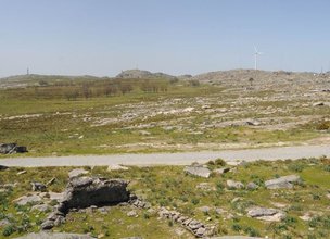
Arga Mountain plateau: a dramatic landform.
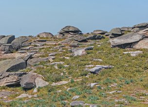
Arga Mountain has a plateau about 800 meters high, the same altitude as the one presented by the most regular and well-preserved rocky sectors of inner regions of the Iberian Peninsula (esq. A).
The strong erosion in the region led to the formation of a vast flat surface near sea level about 80 million years ago (esq. BA). Afterwards, tectonics lifted the surface, known as the Iberian Meseta, to its current altitude (esq. BB). With time, part of the Iberian Meseta disappeared as a consequence of erosion and river incision. The flattened top of Arga Mountain is a remnant from the time when tectonics lifted the Iberian Peninsula to its highest altitude. Thus, Arga Mountain is a granitic residual landscape with a very particular meaning.
Small landforms.
In the Arga Mountain plateau, and particularly in the area of the peat bogs, there are some small landforms whose origin is related to the prevailing rock type - granite in this case -, the fractures network, weathering, and erosion.
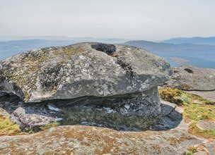
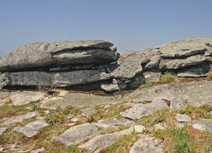
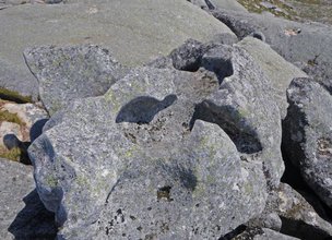
Weathering was particularly significant during subtropical or mild to hot climate that existed in the Iberian Peninsula until about 2.5 million years ago. This circumstance allowed the formation of granite blocks, castle kopje, tors, tafoni, linear joints, etc. that stand out in the landscape (esq. C and Figs 1 to 6). These landforms arose when large quantities of dismantled rock were removed while the surface was being lifted from where it was originally near sea level to its present altitude.
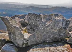
The most striking aspect of the local granitic morphology is the development of pseudo-bedding, which is a type of sub-horizontal fractures (Fig. 4). Pseudo-bedding isolates overlapping rock slabs which can present considerable gaps between them. These and other geomorphological characteristics, such as the development of small cavities and the existence of peat bogs, allow to consider that the landscape has evolved under periglacial climate conditions during the last 2.5 million years. During colder periods, successive temperature variations that originate ice and thaw cycles promoted rock fracturing.
Arga Mountain plateau: a dramatic landform.
Arga Mountain has a plateau about 800 meters high, the same altitude as the one presented by the most regular and well-preserved rocky sectors of inner regions of the Iberian Peninsula (esq. A).
The strong erosion in the region led to the formation of a vast flat surface near sea level about 80 million years ago (esq. BA). Afterwards, tectonics lifted the surface, known as the Iberian Meseta, to its current altitude (esq. BB). With time, part of the Iberian Meseta disappeared as a consequence of erosion and river incision. The flattened top of Arga Mountain is a remnant from the time when tectonics lifted the Iberian Peninsula to its highest altitude. Thus, Arga Mountain is a granitic residual landscape with a very particular meaning.
Small landforms.
In the Arga Mountain plateau, and particularly in the area of the peat bogs, there are some small landforms whose origin is related to the prevailing rock type - granite in this case -, the fractures network, weathering, and erosion.
Weathering was particularly significant during subtropical or mild to hot climate that existed in the Iberian Peninsula until about 2.5 million years ago. This circumstance allowed the formation of granite blocks, castle kopje, tors, tafoni, linear joints, etc. that stand out in the landscape (esq. C and Figs 1 to 6). These landforms arose when large quantities of dismantled rock were removed while the surface was being lifted from where it was originally near sea level to its present altitude.
The most striking aspect of the local granitic morphology is the development of pseudo-bedding, which is a type of sub-horizontal fractures (Fig. 4). Pseudo-bedding isolates overlapping rock slabs which can present considerable gaps between them. These and other geomorphological characteristics, such as the development of small cavities and the existence of peat bogs, allow to consider that the landscape has evolved under periglacial climate conditions during the last 2.5 million years. During colder periods, successive temperature variations that originate ice and thaw cycles promoted rock fracturing.

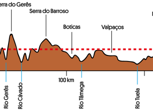
Esq. A - Arga Mountain plateau is a rare remnant of the surface of the Iberian Meseta, which reaches 800 meters, its highest altitude, in the inner part of the Iberian Peninsula.
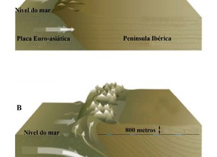
Esq. B - Simplified scheme showing the rise of the Iberian Meseta by tectonics.
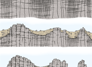
Esq. C - Evolution of granite landforms due to erosion.
Location
Sra. do Minho, Montaria
Coordinates
Lat: 41.800616
Long: -8.688339
 Theme
Theme
 Point of interest

Hello little one!
I'm Piquinhos and I can help you learn more about the Geopark!

Technical details
Esq. A - Arga Mountain plateau is a rare remnant of the surface of the Iberian Meseta, which reaches 800 meters, its highest altitude, in the inner part of the Iberian Peninsula.
Esq. B - Simplified scheme showing the rise of the Iberian Meseta by tectonics.
Esq. C - Evolution of granite landforms due to erosion.
Child Mode
Discover the geopark in a simpler format, aimed at the little ones.
Clique ENTER para pesquisar ou ESC para sair