
Carreço trails
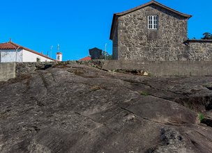
The pedestrian trail "Trilho da Chão" (Plain trail) is a short-distance trail (PR8 - portuguese acronym), marked and signaled according to international guidelines. This trail is located in the parish of Carreço, Viana do Castelo Municipality and starts and ends at the Society of Instruction and Recreation of Carreço, passing through the plateau of the Santa Luzia mountain, along the hillside, through traditional paths (cobblestone sidewalks), with an appreciable gap, offset by wonderful panoramic views.
The "Chão", popularly known as "Chã" (Plain), plateau of Santa Luzia mountain, covers private and vacant lots in the parishes of Carreço, Outeiro, Areosa and Perre. It has been used since ancient times for cattle grazing, as well as a supplier of the wild bushes necessary for the manufacture of manure, organic and natural fertilizer for the agricultural lands of the region.
Datasheet PR8 - Carreço Plain trail
Duration: 6h00m
Distance: 18,34 km
Difficulty level: Moderate
Category: Circular
Starting point: 41.749553, -8.863914
Route in KMZ format for download: KMZ_PR8 TRILHO DA CHAO DE CARREÇO

Location
Carreço
Coordinates
Lat: 41.750061
Long: -8.863653
 Theme
Theme
 Point of interest

Hello little one!
I'm Piquinhos and I can help you learn more about the Geopark!

Technical details
Child Mode
Discover the geopark in a simpler format, aimed at the little ones.
Clique ENTER para pesquisar ou ESC para sair