
Montaria trails
The Pincho pedestrian trail is a short-distance trail (PR5 - portuguese acronym), integrated in the Municipal Network of Pedestrian trails of Viana do Castelo, marked and signaled according to international guidelines. The numbering is assigned by the Municipality of Viana do Castelo.
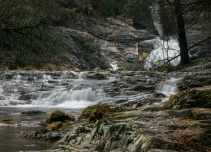
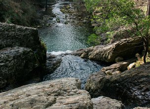
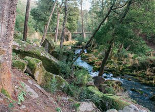
This trail is located in the parish of S. Lourenço da Montaria, Viana do Castelo Municipality, a typical mountain village that brings together the most authentic, bucolic and picturesque features in Alto Minho. Located on the western slope of the mountain, it is the ultimate exponent of rurality with ways of life passed down from generation to generation over the centuries. Its strong mountain character is also reflected in the architecture, where shale mixed with granite contrasts with the terraces used for agriculture, in the conduction of water for irrigation and watermills.
Datasheet PR5 - Pincho trail
Duration: 2h40m
Distance: 9,7 km
Initial height: 274m
Minimum height: 290 m
Maximum height: 100m
Difficulty level: Easy
Category: Circular
Starting point: 41.791306, -8.728750
Informative leaflet: PR 5 - TRILHO DO PINCHO
Route in KMZ format for download: KMZ_PR5 TRILHO DO PINCHO
The Pincho pedestrian trail is a short-distance trail (PR5 - portuguese acronym), integrated in the Municipal Network of Pedestrian trails of Viana do Castelo, marked and signaled according to international guidelines. The numbering is assigned by the Municipality of Viana do Castelo.
This trail is located in the parish of S. Lourenço da Montaria, Viana do Castelo Municipality, a typical mountain village that brings together the most authentic, bucolic and picturesque features in Alto Minho. Located on the western slope of the mountain, it is the ultimate exponent of rurality with ways of life passed down from generation to generation over the centuries. Its strong mountain character is also reflected in the architecture, where shale mixed with granite contrasts with the terraces used for agriculture, in the conduction of water for irrigation and watermills.
Datasheet PR5 - Pincho trail
Duration: 2h40m
Distance: 9,7 km
Initial height: 274m
Minimum height: 290 m
Maximum height: 100m
Difficulty level: Easy
Category: Circular
Starting point: 41.791306, -8.728750
Informative leaflet: PR 5 - TRILHO DO PINCHO
Route in KMZ format for download: KMZ_PR5 TRILHO DO PINCHO

Location
Montaria
Coordinates
Lat: 41.791158
Long: -8.728672
 Theme
Theme
 Point of interest

Hello little one!
I'm Piquinhos and I can help you learn more about the Geopark!

Technical details
Child Mode
Discover the geopark in a simpler format, aimed at the little ones.
Clique ENTER para pesquisar ou ESC para sair