Canto Marinho
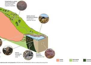
Accordingly to Carvalhido (2008) the main distinctive features of the Local Natural Monument of Magmatic Drops in Canto Marinho landscape, of medium scale, such as granitic balls, and of detail, such as mineralogical varieties or folds, are due to the first stages of the closing of the primitive ocean, the Rheic (the records of its biodiversity and dynamics can be seen in the Local Natural Monument of Rheic Remains in Pedras Ruivas), initiated about 400 million years ago.
The crenulations and folds, also in sheaths, which give a sinuous undulation to the whitish-yellow rocks that make up much of the local substrate (quartzite), were generated in the margin lands, in the first collision phase of the primitive continents, by shortening the space, heating and dragging.
With the new impulses, the amalgamation originated the fusion of rocks and the formation of magma whose cooling, at several kilometres of depth, originated the granites that currently form the hills of St. Luzia and Arga, but also the elevation of the coastal hills of Montedor and Gelfa.
Migrating like hot air balloons through the quartzite, giant drops of magma flowed from the main magma chamber that originated Montedor (Local Natural Monument of Ancient Beaches of Alcantilado de Montedor), and through fractures consolidated here, at about 700 m.
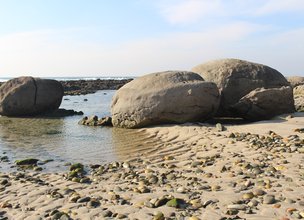
After about 300 million years of erosive processes and tectonic uplifting, we can see the minerals witnessing the hot contact of magma (contact metamorphism) such as garnet and staurolite, and the granite balls, some with more than 10 tons, which were interpreted as a deposit (tsunamite) generated by the oldest tsunami recorded in the Portuguese seismic catalogues, from 66 BC (Baptista & Miranda, 2009).
References:
Baptista, M. & Miranda J. (2009). Revision of the Portuguese catalog of tsunamis. Natural Hazards and Earth System Sciences, 9, pp. 25-42
Carvalhido (2018). Livro de Pedra, Monumentos Naturais Locais de Viana do Castelo – Catálogo. Câmara Municipal de Viana do Castelo, 2ª edição

Magma migration
Location
Canto Marinho
Coordinates
Lat: 41.7414003
Long: -8.8762137
Hello little one!
I'm Piquinhos and I can help you learn more about the Geopark!
Technical details
Diffuse magma migration
The first stages of the closure of the primitive ocean, the Rheic, which started about 400 million years ago, gave rise to the main distinctive features of the LNM Canto Marinho landscape.
In terms of mineralogical interest, the occurrence of typical middle-grade contact metamorphism occurs, such as garnet and staurolite, which are exclusive to this area of the Viana do Castelo coast. They are indicators, together with those of tectonics - occurrence of folds with very inclined axial planes - of the pressure and the important heat transfer resulting from the proximity to the intrusion of the plutonite of Bouça de Frade (main coastal outcrop in the Montedor Cliff) (Carvalhido, 2018 ). Of residual interest is the occurrence of granite blocks, some with more than 10 tons), which are an excellent example of one of the mechanisms of regional magmatic installation, namely the diffuse magma migration (Carvalhido, 2018) and which came to be interpreted as a deposit (tsunamite) generated by the oldest tsunami of which there is a record in Portuguese seismic catalogs, from 60 BC (Baptista & Miranda, 2009).
References:
Baptista, M. & Miranda J. (2009). Revision of the Portuguese catalog of tsunamis. Natural Hazards and Earth System Sciences, 9, pp. 25-42
Carvalhido (2018). Livro de Pedra, Monumentos Naturais Locais de Viana do Castelo – Catálogo. Câmara Municipal de Viana do Castelo, 2ª edição
References and scientific articles
Baptista, M. & Miranda J. (2009). Revision of the Portuguese catalog of tsunamis. Natural Hazards and Earth System Sciences, 9, pp. 25-42
Carvalhido (2018). Livro de Pedra, Monumentos Naturais Locais de Viana do Castelo – Catálogo. Câmara Municipal de Viana do Castelo, 2ª edição
Magma migration
Child Mode
Discover the geopark in a simpler format, aimed at the little ones.
Clique ENTER para pesquisar ou ESC para sair
